South Col – South East Ridge Route – part 6.
Summit Day.
From Camp 4, climbers will begin their summit push around midnight with hopes of reaching the summit (still another 1,000 metres above) within 10 to 12 hours. Climbers will first reach “The Balcony” at 8,400 m (27,600 ft), a small platform where they can rest and gaze at peaks to the south and east in the early dawn light. 
Continuing up the ridge, climbers are then faced with a series of imposing rock steps which usually forces them to the east into waist deep snow, a serious avalanche hazard. At 8,750 m (28,700 ft), a small table-sized dome of ice and snow marks the South Summit.

From the South Summit, climbers follow the knife-edge southeast ridge along what is known as the “Cornice  traverse” where snow clings to intermittent rock. This is the most exposed section of the climb as a misstep to the left would send one 2,400 m (8,000 ft) down the southwest face while to the immediate right is the 3,050 m (10,000 ft) Kangshung face. At the end of this traverse is an imposing 12 m (40 ft) rock wall called the “Hillary Step” at 8,760 m (28,740 ft).
After the Hillary Step, climbers also must traverse a very loose and rocky section that has a very large entanglement of fixed ropes that can be troublesome in bad weather. Climbers will typically spend less than a half-hour on the “top of the world” as they realize the need to descend to Camp 4 before darkness sets in, afternoon weather becomes a serious problem, or supplemental oxygen tanks run out.
Everest South Col – South East Ridge Route – part 6 by http://www.alanarnette.com/alan/everestsouthroutes.php
Everest Southeast Ridge.
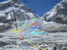
Summit route as seen from camp 4, the South Col. The true summit is not visible from this angle. It was still 10 hours to the summit from where I turned around.
 click to enlarge map
In 2002, we were fortunate that there was no wind – no wind, incredible! And the temps were around zero. It was very comfortable in our down suits. We arrived in C4 between noon and two and rested, drank and ate until 9:00. We were woken up by the Sherpas who then took full control. This was where they shined in interacting with us. While they had been working hard for the past five weeks, we saw them occasionally at BC or other camps and spoke with them rarely. However at C4, they knew each of us and called us by name – as we did them. They checked our crampons for tightness, that our harnesses were doubled-backed and that our Oxygen was set properly with the regulators. They helped us on with packs and then lead the climb to the summit.

It was obviously dark at 10:30PM when we set out. Headlamps lighting up the way, the departure from C4 was like boarding an airplane. Everyone milling around for position and then when one group started, every group started for fear of getting stuck in long lines up the mountain. The frenzy and disorganization was real and alarming considering we had taken six weeks to get to this point! Our team left in small groups, not all together. At this point it felt like ‘every person for themselves’, except for the Sherpas. Each climber had been assigned to a Sherpa. There was Ang Dorge in the lead, Sherpas assigned to the middle and one bringing up the rear. So actually, each climber had several eyes upon them the entire time. Also each Sherpa and Guide had a radio.
We started up the Southeast ridge towards the balcony. The activity was fast paced. Climbers passing climbers. People stopping to adjust Oxygen or gear. The lines took over two hours to spread out. At some points you simply stood in place waiting for the person ahead of you to move, not wanting -or able -to pass them.
It was about two hours in that I started to feel worse. Extreme coughing episodes ending with vomiting or gagging. I continued like this over another hour when I concluded that I would never make the summit and going higher would put me, my Sherpas and the team at risk. I made the decision to turn around at that point. It ended up that I had contracted a lung infection a few days earlier and it was preventing my lungs from working properly thus causing fatigue and dehydration. Upon my return to BC, three days later, the expedition Doctor heard ‘crackling’ sounds in my lungs and put me on antibiotics immediately. She also gave me two liters of fluids via IV to get me rehydrated. I was in bad shape as it turned out.
Everest Summit Ridge.
Summit Ridge. South Summit on the left. The summit is not in the picture. The lite cloud (plume) is normal and shows some winds but still marginally climbable. This picture was taken from Kala Patar using a 10X optical zoom lens.
A little more on the summit attempt as told to me by friends. The trip from the Balcony to the South Summit was longer than they thought it was not too difficult. There were queues at the South Summit and Hilary Step while Sherpas fixed lines. About 45 minutes each place. The Hilary Step was not bad at all and in fact, easier than the Yellow Band in many’s view. It is a long day, however, very long.
That’s about it. Incredible journey to a unique place. Deserving of every harsh word ever written or said. AND deserving of all the mystique and attraction. Everest is like a magnet to Mountaineers. Be careful what you wish for…
* Source : – http://www.alanarnette.com/
** Previous story :
– Everest South Col – South East Ridge Route – part 1. Droga pierwszych zdobywców Everestu cz.1. /Version english and polish/
– Everest South Col – South East Ridge Route – part 2. Droga pierwszych zdobywców Everestu cz.2. /Version english and polish/
– Everest South Col – South East Ridge Route – part 3. Droga pierwszych zdobywców Everestu cz.3. /Version english and polish/
– Everest South Col – South East Ridge Route – part 4. Droga pierwszych zdobywców Everestu cz.4. /Version english and polish/
– Everest South Col – South East Ridge Route – part 5. Droga pierwszych zdobywców Everestu cz.5. /Version english and polish/
*** see : Mt. Everets web album
– Routes – part 3.Drogi do celu. cz.3. /Version polish and english/
Droga pierwszych zdobywców Everestu cz.6.
Droga z obozu C4 na szczyt czyli Grań Południowo-Wschodnia..
Mapka na początku pokazuje drogę z obozu 4 na szczyt. Ostatni etap wspinaczki to pokonanie Grani Południowo-Wschodniej, na której znajduje się charakterystyczne miejsce zwane Balkonem, gdzie wspinacze odpoczywają przed kolejnym etapem ataku szczytowego oraz mogą nacieszyć się pięknym widokiem na okoliczne szczyty. Osiągnięcie Wierzchołka Południowego to pierwsza wiktoria, która czeka ekipę. Oczom zespołu ukaże się ostatni etap wspinaczki – ośmiometrowy uskok skalny zwany także Stopniem/Uskokiem Hillary’ego.
Agnieszka Kiela-Pałys, która jako czwarta Polka stanęła na szczycie Świata zdobywając Everest 23 maja 2008 o 5:30, tak opisuję swoją wspinaczkę na tym etapie:
“Droga do Balkonu była dość monotonna – zbocze początkowo śnieżne, potem mikstowe – w tym roku było dość mało śniegu i wystawało spod niego dużo skał, przeważnie były to odjazdowe łupki. Jakoś nie miałam do nich przekonania i, ku mojej wielkiej radości, udało nam się dojść do Balkonu po 4 godzinach, zamiast po 6. Chwilę tam odpoczęliśmy i napiliśmy się gorącej herbaty z termosu, ale gdy przestaliśmy się przemieszczać, zrobiło się natychmiast zimno, więc sama nalegałam, żeby już ruszać dalej.
Za Balkonem dogoniliśmy wkrótce grupę zorganizowaną pod wodzą dwóch Szerpów. W sumie było tam około 10 osób; ze względu na dużą liczbę osób ją tworzących poruszała się wolniej niż nasza dwójka, ale teraz szliśmy dość wąską eksponowaną granią, gdzie nie sposób było ich wszystkich wyprzedzić, więc nasze tempo marszu niestety spadło. Okropnie irytowali mnie Szerpowie towarzyszący grupie, którzy co pół godziny stawali, tarasowali przejście i składali przez radio raport komuś czuwającemu w niższym obozie. Robiły się przez to przestoje i zatory, ale nie sposób im było tego wytłumaczyć.
 Grań szczytowa Everestu
W końcu po niecałych 4 godzinach dotarliśmy na Wierzchołek Południowy. Było tam strasznie wietrznie, więc szczęśliwie udało nam się w końcu minąć grupę, która tam zabiwakowała i przejść do naturalnej niszy poniżej, gdzie było znacznie zaciszniej. Zrobiliśmy tam sobie kolejny krótki odpoczynek. Nadal było dość zimno, bo jeszcze nie wstało słońce.
 Uskok Hillarego
Widać już było grań szczytową i wizja właściwego wierzchołka uskrzydlała. Szło mi się doskonale, nadal nie czułam zmęczenia i utrzymywaliśmy niezłe tempo marszu. Na grani spotkaliśmy już sporo innych osób – wszyscy poruszali się w jedynym słusznym kierunku. Pokonywaliśmy grań, mijając kolejne potężne nawisy śnieżne imitujące wierzchołek. Wreszcie Uskok Hillary’ego i niedługo potem ukazał się właściwy szczyt – z powodu ogromnego nagromadzenia chorągiewek nie było wątpliwości, że to to! Jeszcze kilka kroków i wreszcie na nim stanęliśmy. Była 5:30 rano 23. maja. Przed piątą się rozwidniło, po drodze oglądaliśmy piękny wschód słońca, a teraz właśnie przed naszymi oczami roztaczał się najpiękniejszy widok świata, o jakim marzyłam przez lata – Lhotse, Makalu, Cho Oyu – wszystkie te olbrzymy znalazły się teraz poniżej – miałam uczucie, że cały świat znalazł się pod moimi stopami. Z wolna docierało do mnie, że to już, że już nie będę musiała marzyć o tym szczycie, planować, zbierać fundusze… ”

Świat u stóp – widok ze szczytu
* Źródła : – http://www.7summits.pl/ – http://www.alanarnette.com/
** Zobacz też :
– Everest South Col – South East Ridge Route – part 1. Droga pierwszych zdobywców Everestu cz.1. /Version english and polish/
– Everest South Col – South East Ridge Route – part 2. Droga pierwszych zdobywców Everestu cz.2. /Version english and polish/
– Everest South Col – South East Ridge Route – part 3. Droga pierwszych zdobywców Everestu cz.3. /Version english and polish/
– Everest South Col – South East Ridge Route – part 4. Droga pierwszych zdobywców Everestu cz.4. /Version english and polish/
– Everest South Col – South East Ridge Route – part 5. Droga pierwszych zdobywców Everestu cz.5. /Version english and polish/
– Routes – part 3.Drogi do celu. cz.3. /Version polish and english/
– Everest marzenie wielu… web album


** zapraszam na relacje z wypraw polskich himalaistów.


zapraszam do subskrypcji mego bloga
Filed under: Climbers, Expedition, Himalayas, Routes, Travel | Tagged: Balcony, Base Camp, Climbers, Everest, Expedition, Hillary Step, Khumbu glacier, Khumbu Icefall, Lhotse, Nepal, route, South Col, South East Ridge, South Summit, Travel | Leave a comment »


 Let’s take a look at the climb above C3 and onto the South Col. As I have said before the terrain starts out fairly steep from C3. Most climbers are on supplemental oxygen and leave their tents after sunrise. It can be extremely cold before the sun moves over Lhotse and if the winds are the least bit strong, it is miserable. But as soon as the sun hits, and there are no clouds, then it can become horribly hot. Many climbers are in their full down suits trying to minimize the weight in their packs.
 defining the South Col. This is actually on the Geneva Spur. Climbers are a little weary at this point more from the altitude than anything else so when they see 150′ of 60 degree rock, ice and snow, it causes a long pause. But it is actually easier than it looks. From all the traffic, there are decent steps but also the uneven rock allows for good foot placement. In low snow years, this area may be snowfree and clibmers remove their crampons to make it easier.

 Climbing the Lhotse Face is a big challenge after the Khumbu Ice Fall on the way to the summit. There are many ropes attached to the face with ice screws and anchors. Each rope is about 200′ long so climbers must unclip their carabineers and jumars at each junction. This is a two step process so that the climber is always attached to the fixed line by at least one device. It is very normal for a long line of climbers to be going up and another long line coming down – usually Sherpas returning from carrying loads to the higher camps. So, in the middle of the Himalayas, you have a traffic jam!
 closer, you make your move to the right or left. Standing close to each other, you make sure your footing is fixed. With a few grunts and a smile, you unclip one of your carabineers keeping the other one attached to the lifeline. Reaching around the climber, you clip back into the line around him, then move the other ‘biner above this new placement. All this happens in a moment and you move on. Not every swap is this complex but everyone requires caution. One mistake and there is no recovery on the steep Face. Once you start to fall, there is nothing to stop you for thousands of feet. It is real. It is harsh. It is climbing Everest.